Order Total (1 Item Items):
Shipping Destination:

Compiled Drawn Cartographic Section National (11 results)
Skip to main search results
Product Type
- All Product Types
- Books
- Magazines & Periodicals
- Comics
- Sheet Music
- Art, Prints & Posters
- Photographs
- Maps (11)
- Manuscripts & Paper Collectibles
Condition
Binding
- All Bindings
- Hardcover
- Softcover (10)
Collectible Attributes
- First Edition (11)
- Signed
- Dust Jacket
- Seller-Supplied Images (1)
- Not Print on Demand (11)
Free Shipping
- Free US Shipping
Seller Location
Seller Rating
-

West Indies : The National Geographic Magazine
Published by National Geographic Society, Washington D.C, 1954
Seller: J J Basset Books, bassettbooks, bookfarm.co.uk, Peter Tavy, United Kingdom
Seller Rating:

Map First Edition
Fold Out Map. Condition: Near Fine. No Jacket. Compiled & Drawn in the Cartographic Section of the National Geographic Society (illustrator). First Edition. Please Email for further details. Size: 8vo - over 7�" - 9�" (Folded). Not Signed or Inscribed. Fold Out Map.
-
The World Map : The National Geographic Magazine
Published by National Geographic Society, Washington D.C, 1951
Seller: J J Basset Books, bassettbooks, bookfarm.co.uk, Peter Tavy, United Kingdom
Seller Rating:
Map First Edition
Fold Out Map. Condition: Very Good. No Jacket. Compiled & Drawn in the Cartographic Section of the National Geographic Society (illustrator). First Edition. Please Email for further details. Size: 8vo - over 7�" - 9�" (Folded). Not Signed or Inscribed. Fold Out Map.
-
North America : The National Geographic Magazine Vol C1 No. 3
Published by National Geographic Society, Washington D.C, 1952
Seller: J J Basset Books, bassettbooks, bookfarm.co.uk, Peter Tavy, United Kingdom
Seller Rating:
Map First Edition
Fold Out Map. Condition: Near Fine. No Jacket. Compiled & Drawn in the Cartographic Section of the National Geographic Society (illustrator). First Edition. Please Email for further details. Size: 8vo - over 7�" - 9�" (Folded). NOT SIGNED OR INSCRIBED. Fold Out Map.
-
Northern Europe : The National Geographic Magazine
Published by National Geographic Society, Washington D.C, 1954
Seller: J J Basset Books, bassettbooks, bookfarm.co.uk, Peter Tavy, United Kingdom
Seller Rating:
Map First Edition
Fold Out Map. Condition: Very Good Closed Tears. No Jacket. Compiled & Drawn in the Cartographic Section of the National Geographic Society (illustrator). First Edition. Please Email for further details. Size: 8vo - over 7�" - 9�" (Folded). Not Signed or Inscribed. Fold Out Map.
-
Central Europe Including the Balkan States : The National Geographic Magazine
Published by National Geographic Society, Washington D.C, 1951
Seller: J J Basset Books, bassettbooks, bookfarm.co.uk, Peter Tavy, United Kingdom
Seller Rating:
Map First Edition
Fold Out Map. Condition: Near Fine. No Jacket. Compiled & Drawn in the Cartographic Section of the National Geographic Society (illustrator). First Edition. Please Email for further details. Size: 8vo - over 7�" - 9�" (Folded). Not Signed or Inscribed. Fold Out Map.
-
Africa and the Arabian Peninsula : The National Geographic Magazine
Published by National Geographic Society, Washington D.C, 1950
Seller: J J Basset Books, bassettbooks, bookfarm.co.uk, Peter Tavy, United Kingdom
Seller Rating:
Map First Edition
Fold Out Map. Condition: Near Fine. No Jacket. Compiled & Drawn in the Cartographic Section of the National Geographic Society (illustrator). First Edition. Please Email for further details. Size: 8vo - over 7�" - 9�" (Folded). Not Signed or Inscribed. Fold Out Map.
-
Mexico and Central America : The National Geographic Magazine Vol CIII No. 3
Published by National Geographic Society, Washington D.C, 1953
Seller: J J Basset Books, bassettbooks, bookfarm.co.uk, Peter Tavy, United Kingdom
Seller Rating:
Map First Edition
Fold Out Map. Condition: Near Fine. No Jacket. Compiled & Drawn in the Cartographic Section of the National Geographic Society (illustrator). First Edition. Please Email for further details. Size: 8vo - over 7�" - 9�" (Folded). Not Signed or Inscribed. Fold Out Map.
-
South America : The National Geographic Magazine Vol XCVIII No.4
Published by National Geographic Society, Washington D.C, 1950
Seller: J J Basset Books, bassettbooks, bookfarm.co.uk, Peter Tavy, United Kingdom
Seller Rating:
Map First Edition
Fold Out Map. Condition: Near Fine. No Jacket. Compiled & Drawn in the Cartographic Section of the National Geographic Society (illustrator). First Edition. Please Email for further details. Size: 8vo - over 7�" - 9�" (Folded). Not Signed or Inscribed. Fold Out Map.
-
The Far East : The National Geographic Magazine
Published by National Geographic Society, Washington D.C, 1952
Seller: J J Basset Books, bassettbooks, bookfarm.co.uk, Peter Tavy, United Kingdom
Seller Rating:
Map First Edition
Fold Out Map. Condition: Near Fine. No Jacket. Compiled & Drawn in the Cartographic Section of the National Geographic Society (illustrator). First Edition. Please Email for further details. Size: 8vo - over 7�" - 9�" (Folded). Not Signed or Inscribed. Fold Out Map.
-
Atlantic Ocean : The National Geographic Magazine
Published by National Geographic Society, Washington D.C, 1955
Seller: J J Basset Books, bassettbooks, bookfarm.co.uk, Peter Tavy, United Kingdom
Seller Rating:
Map First Edition
Fold Out Map. Condition: Very Good. No Jacket. Compiled & Drawn in the Cartographic Section of the National Geographic Society (illustrator). First Edition. Please Email for further details. Size: 8vo - over 7�" - 9�" (Folded). Not Signed or Inscribed. Fold Out Map.
-
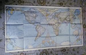
A Map of the World; Rare Excl. cond. December 1941
Published by National Geographic Society (U.S.), 1941
Map First Edition
No Binding. Condition: Very Good. 1st Edition. A Map of the World; sheet map (folded) Excellent no marks supple paper no pin holes at corners. Grosvenor, Gilbert [Editor] | Darley, James M [Cartographer] Material type: Map Map Publisher: Washington, D.C. : National Geographic Society, 1941 Description: 1 map : color ; 2 hemispheres, each 50 cm in diam., on sheet 56 x 104 cm, folded to 16 x 21 cm James Darley, Chief Cartographer. , Scale 1:35,000,000 ; Azimuthal equal area projection; (W 180°--E 180°/N 90°--S 90°). - 1 map : color ; 2 hemispheres, each 50 cm in diam., on sheet 56 x 104 cm, folded to 16 x 21 cm Relief shown by hachures and spot heights. "International boundaries as of Sept. 1, 1939." "December, 1941." Ancillary maps: World mapping -- Time zones -- Land hemisphere -- Water hemisphere -- Density of population (Western hemisphere) -- Density of population (Eastern hemisphere). Insets: Land Hemisphere -- World mapping -- Water hemisphere -- Time zones -- Density of population.